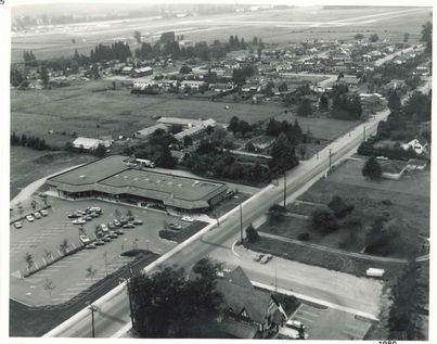
{"STATUS":"SUCCESS","ID":"303","LATITUDE":"49.2223960209563","LONGITUDE":"-122.68992805238","TYPE":"locations-mark","NAME":"Aerial of Ford Road","CONTENT":"This is a black and white oblique aerial of Ford Road in 1980. This area has seen a lot of change, what can you see that’s different?","SEO_LINK":"aerial-of-ford-road","VIDEO_LINK":"","SOUNDCLOUD_LINK":"","IMG1":"1661712654_main_aerial-of-ford-road_1.jpg","IMG2":"","IMG3":"","IMG4":"","IMG5":"","IMG6":"","IMG7":"","IMG1_THUMB":"1661712654_thumb_aerial-of-ford-road_1.jpg","IMG2_THUMB":"","IMG3_THUMB":"","IMG4_THUMB":"","IMG5_THUMB":"","IMG6_THUMB":"","IMG7_THUMB":""}X

Aerial of Ford Road


This is a black and white oblique aerial of Ford Road in 1980. This area has seen a lot of change, what can you see that’s different?


Details:

Latitude: 49.2223960209563

Longitude: -122.68992805238

Direct Link: https://www.pittmeadowsmuseum.com/locations/aerial-of-ford-road

top border
logo

Welcome to the Pitt Meadows Museum and Archive's Memories Mapping Project!

Click on the map to add your history or explore what others have left.

This project funded in part by:
Government of British Columbia
BC | Canada 150 Grants