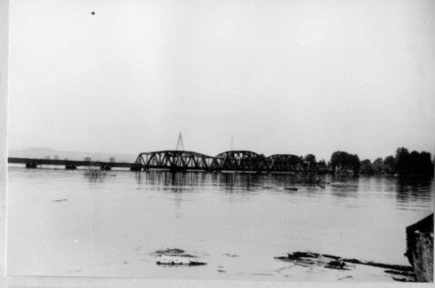
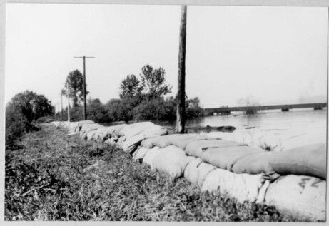
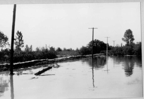
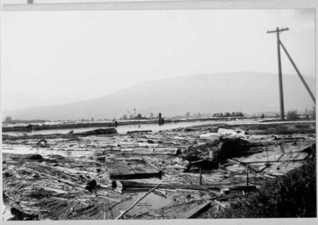
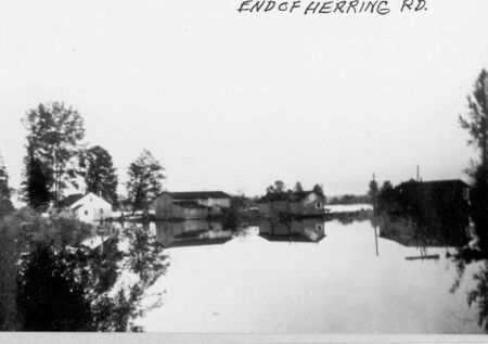
All of these photographs are from the 1948 flood and come from the Kennedy family. The first photograph is shot from the Pitt Meadows side of the river, just upstream from the bridge on Kennedy farm land. The second and third photo is the dyke at the Robert and Fanny Kennedy Farm later the Arthur Kennedy farm. The last two photographs are from the flood with no information.<\/p>\r\n
<\/p>\r\n
Flooding and The Pitt Meadows Day That Never Came<\/p>\r\n
<\/p>\r\n
At one time flooding was such a natural occurrence in the low lands of Pitt Meadows that one very early settler, Don McLean, once wrote that when he was a child his family kept their piano up on blocks to keep it safe from the spring flooding of the Fraser and Pitt Rivers. At one time, due to high water tables and copious amounts of rain, floods could occur at any time of the year in this area, but the worst always occurred during the spring freshets in May and June. Now, due to modern dyking techniques (first introduced to the area by the Dutch) that have been employed since the middle of the 20th century, these high waters go practically unnoticed by people living in the community but for the 100 years prior to that the history of Pitt Meadows is punctuated with stories of the settlers’ battle to keep the water at bay.<\/p>\r\n
<\/p>\r\n
The flood of 1948 and the cancellation of Pitt Meadows Day is just one of these stories. Traditionally held sometime in the first week of June, the 1948 Pitt Meadows Day was on a collision course with the highest river water levels this area had seen in decades. If it had been a year like all others, the event would likely have taken place sometime between late May and the end of the first week in June but in 1948 flood preparation and relief efforts consumed the community thereby requiring the cancellation of the event. Now we know that the event was actually cancelled due to lack of parent interest, but that is not the story most people want to hear as it is such a huge event now.<\/p>\r\n
<\/p>\r\n
So what was happening in the town during that period? In 1948 Pitt Meadows was a small, agriculturally based community with a population of fewer than 1400 people. The area was and is surrounded by rivers on three sides and much of the land is lowland and was prone to flooding in the spring. In 1948 the earthen dyking system that protected Pitt Meadows’ lowlands was about 25 miles (40 kilometers) long and was built in a u-shape along the Alouette, Pitt and Fraser Rivers. On May 28th, following a period of very warm weather, the dyke on the Alouette gave way and 7,000 acres of land were flooded in the northern sector of the community, necessitating the evacuation of cattle and residents to higher ground. The municipal hall and community centre (now the Heritage Hall),usually the centre for Pitt Meadows Day festivities, was taken over by B.C. Police Constable Kelly Irvine and his volunteer flood-fighters who coordinated their efforts out of the building. Over the next number of days workers reinforced dykes using truck loads of sand while others walked the dykes around the clock checking for holes and other leaks. Many of these volunteer flood fighters worked 24 to 36 hour shifts until the army arrived to assist with the fortification of the dykes.<\/p>\r\n
<\/p>\r\n
Back at the Hall women were also part of the flood fight. Many of these women were part of the Women’s Institute, the group who generally spent that time of year preparing for and carrying out Pitt Meadows Day. In 1948 these women toiled around the clock beside the ladies of the Red Cross feeding the flood fighters, often preparing as many as 300 meals per day as well as hundreds of sandwiches and gallons of coffee. With the arrival of June the Fraser River had become the centre of concern in Pitt Meadows and by June 3rd the water was lapping at the top of the dykes in the Baynes Road area. That evening the dyke on the north side of Barnston Island gave way taking the pressure off the dykes on the Pitt Meadows side and the water lowered by inches. It would seem the worst was over and the cleanup would soon begin. While there was no Pitt Meadows Day in 1948, the community did celebrate a bit on July 3rd when the Pitt Meadows Athletic Association and the Gun Club organized a dance that raised more than $100.00 to go towards the reconditioning of the floors in the Hall’s auditorium as they had been so badly damaged by the hob-nailed boots worn by the flood fighters. (extracted in part from an article by L. Norman, Pitt Meadows Museum for the News Newspaper, June, 2007)<\/p>\r\n
<\/p>\r\n
When we near May, the high snow pack and warm weather always leads to talk of higher than normal rivers. Fear not, our dykes are now built to withstand the spring freshets and pianos need not be put up on blocks.<\/p>","SEO_LINK":"flooding-and-the-pitt-meadows-day-that-never-came","VIDEO_LINK":"","SOUNDCLOUD_LINK":"","IMG1":"1661710958_main_flooding-and-the-pitt-meadows-day-that-never-came_1.jpg","IMG2":"1661710958_main_flooding-and-the-pitt-meadows-day-that-never-came_2.jpg","IMG3":"1661710958_main_flooding-and-the-pitt-meadows-day-that-never-came_3.jpg","IMG4":"1661710959_main_flooding-and-the-pitt-meadows-day-that-never-came_4.jpg","IMG5":"1661710959_main_flooding-and-the-pitt-meadows-day-that-never-came_5.jpg","IMG6":"","IMG7":"","IMG1_THUMB":"1661710958_thumb_flooding-and-the-pitt-meadows-day-that-never-came_1.jpg","IMG2_THUMB":"1661710958_thumb_flooding-and-the-pitt-meadows-day-that-never-came_2.jpg","IMG3_THUMB":"1661710958_thumb_flooding-and-the-pitt-meadows-day-that-never-came_3.jpg","IMG4_THUMB":"1661710959_thumb_flooding-and-the-pitt-meadows-day-that-never-came_4.jpg","IMG5_THUMB":"1661710959_thumb_flooding-and-the-pitt-meadows-day-that-never-came_5.jpg","IMG6_THUMB":"","IMG7_THUMB":""}X
Flooding and the Pitt Meadows Day that never came
All of these photographs are from the 1948 flood and come from the Kennedy family. The first photograph is shot from the Pitt Meadows side of the river, just upstream from the bridge on Kennedy farm land. The second and third photo is the dyke at the Robert and Fanny Kennedy Farm later the Arthur Kennedy farm. The last two photographs are from the flood with no information.
Flooding and The Pitt Meadows Day That Never Came
At one time flooding was such a natural occurrence in the low lands of Pitt Meadows that one very early settler, Don McLean, once wrote that when he was a child his family kept their piano up on blocks to keep it safe from the spring flooding of the Fraser and Pitt Rivers. At one time, due to high water tables and copious amounts of rain, floods could occur at any time of the year in this area, but the worst always occurred during the spring freshets in May and June. Now, due to modern dyking techniques (first introduced to the area by the Dutch) that have been employed since the middle of the 20th century, these high waters go practically unnoticed by people living in the community but for the 100 years prior to that the history of Pitt Meadows is punctuated with stories of the settlers’ battle to keep the water at bay.
The flood of 1948 and the cancellation of Pitt Meadows Day is just one of these stories. Traditionally held sometime in the first week of June, the 1948 Pitt Meadows Day was on a collision course with the highest river water levels this area had seen in decades. If it had been a year like all others, the event would likely have taken place sometime between late May and the end of the first week in June but in 1948 flood preparation and relief efforts consumed the community thereby requiring the cancellation of the event. Now we know that the event was actually cancelled due to lack of parent interest, but that is not the story most people want to hear as it is such a huge event now.
So what was happening in the town during that period? In 1948 Pitt Meadows was a small, agriculturally based community with a population of fewer than 1400 people. The area was and is surrounded by rivers on three sides and much of the land is lowland and was prone to flooding in the spring. In 1948 the earthen dyking system that protected Pitt Meadows’ lowlands was about 25 miles (40 kilometers) long and was built in a u-shape along the Alouette, Pitt and Fraser Rivers. On May 28th, following a period of very warm weather, the dyke on the Alouette gave way and 7,000 acres of land were flooded in the northern sector of the community, necessitating the evacuation of cattle and residents to higher ground. The municipal hall and community centre (now the Heritage Hall),usually the centre for Pitt Meadows Day festivities, was taken over by B.C. Police Constable Kelly Irvine and his volunteer flood-fighters who coordinated their efforts out of the building. Over the next number of days workers reinforced dykes using truck loads of sand while others walked the dykes around the clock checking for holes and other leaks. Many of these volunteer flood fighters worked 24 to 36 hour shifts until the army arrived to assist with the fortification of the dykes.
Back at the Hall women were also part of the flood fight. Many of these women were part of the Women’s Institute, the group who generally spent that time of year preparing for and carrying out Pitt Meadows Day. In 1948 these women toiled around the clock beside the ladies of the Red Cross feeding the flood fighters, often preparing as many as 300 meals per day as well as hundreds of sandwiches and gallons of coffee. With the arrival of June the Fraser River had become the centre of concern in Pitt Meadows and by June 3rd the water was lapping at the top of the dykes in the Baynes Road area. That evening the dyke on the north side of Barnston Island gave way taking the pressure off the dykes on the Pitt Meadows side and the water lowered by inches. It would seem the worst was over and the cleanup would soon begin. While there was no Pitt Meadows Day in 1948, the community did celebrate a bit on July 3rd when the Pitt Meadows Athletic Association and the Gun Club organized a dance that raised more than $100.00 to go towards the reconditioning of the floors in the Hall’s auditorium as they had been so badly damaged by the hob-nailed boots worn by the flood fighters. (extracted in part from an article by L. Norman, Pitt Meadows Museum for the News Newspaper, June, 2007)
When we near May, the high snow pack and warm weather always leads to talk of higher than normal rivers. Fear not, our dykes are now built to withstand the spring freshets and pianos need not be put up on blocks.
Details:
Latitude: 49.2431044103695
Longitude: -122.73168992389
Direct Link: https://www.pittmeadowsmuseum.com/locations/flooding-and-the-pitt-meadows-day-that-never-came
