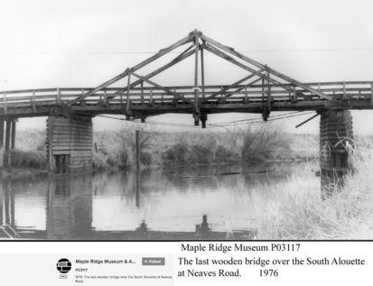
Neaves Bridge
I used to go swimming there when I was a kid in the mid to late 1950's. L. Petit
Details:
Latitude: 49.2487254842234
Longitude: -122.64647756470
Direct Link: https://www.pittmeadowsmuseum.com/locations/neaves-bridge
I used to go swimming there when I was a kid in the mid to late 1950's. L. Petit
Details:
Latitude: 49.2487254842234
Longitude: -122.64647756470
Direct Link: https://www.pittmeadowsmuseum.com/locations/neaves-bridge

Welcome to the Pitt Meadows Museum and Archive's Memories Mapping Project!
Click on the map to add your history or explore what others have left.
This project funded in part by:
Government of British Columbia
BC | Canada 150 Grants